Snowdonia Mapping - with hillshading May 07 2018
This weekend, some of the Love Maps On team took a trip to the breathtaking Snowdonia National Park where we were lucky enough to enjoy the higher than average temperatures the UK has had this Bank Holiday weekend.
We'd dusted off our walking boots and had already prepared a Love Maps On print of the area using OS Explorer Mapping with our added Digital Hillshading.
We chose a route which took us from a Roman camp via the Miners' Track to the abandoned copper mine workings close to the jagged peak of Snowdon. Of course we weren't the only ones - the paths were busy with visitors making their way up to the Snowdon summit.


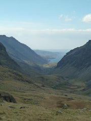
After finding a sheltered spot by Llyn Llydaw for our picnic, we continued to climb before looping back on the Pyg Track for views over the Pass of Llanberis and returning to our start point.
Our Love Maps On Ordnance Survey Explorer Map with added digital hillshading really helped us understand the complex topography of our immediate surroundings in a way that our other map-based hand-held tech just couldn't manage. See how digital hillshading can add texture and depth to your map here.
Such a beautiful landscape.

