Blog
Hill-shaded OS maps for trail runners and walkers October 14 2019
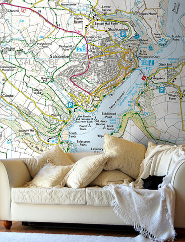
If you love hiking or running in the hills then one of our customised hill-shaded Ordnance Survey map wallpapers could be just the thing to inspire you and help you to plan your routes. The hill shading accentuates the terrain, to give the map a feeling of depth on your wall.

Trail runners are a particularly hardy bunch, getting out into the hills all year round. Trail Running Magazine tested the map wallpaper and after hanging a map of her local area on the wall, Editor Claire Maxted said
“Awesome! Now I can see all the trails in my area at a glance, plus the lumpy bits stand out brilliantly with the hill-shading!”
The wallpaper is backed with self-adhesive so that you can stick it onto a prepared wall with no glue needed. As you add each adjoining length of wallpaper, you can unstick it and reposition it to ensure that the map is lined up across the joins in the paper. To see Claire’s tips for hanging the wallpaper, watch her YouTube video https://www.youtube.com/watch?v=3s3Juv9g7O8
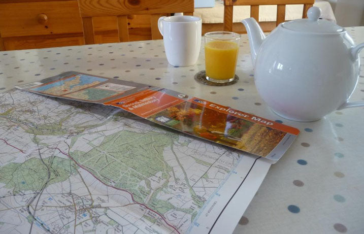
If you’d like a map on your walls to plan your routes in the hills, we can print a map centred on the postcode of your choice in England, Scotland or Wales using the Ordnance Survey 1:50 000 Landranger® or 1:25 000 Explorer® style mapping.
Simply provide us with the postcode on which you’d like us to centre your map, specify the Ordnance Survey map style you prefer and select one of our standard wallpaper sizes. We’ll send you a proof showing the image that will be printed on your wallpaper for approval. We can also produce made-to-measure wallpaper, please read our wallpaper tips and provide the measurements of your wall in our quote form.
Ships, clock and stars: The Quest for Longitude March 09 2015
Last year marked the 300th anniversary of the passing of the Longitude Act in 1714, and the National Maritime Museum Greenwich hosted ‘Ships, Clocks & Stars: The Quest for Longitude’, an exhibition telling the extraordinary story of the race to determine longitude at sea. The race was eventually won by an extraordinary engineer, John Harrison whose maritime timepieces go back on display at the Royal Observatory in Greenwich on 16th March. We love a tale of danger on the high seas and an epic quest by a heroic figure. For us, the story of John Harrison’s lifelong dedication to accurate maritime timekeeping for measuring longitude is a compelling quest and Harrison is a hero of engineering, navigation and seafaring.


Exhibition promotion at the National Maritime Museum The Royal Observatory, Greenwich
For millennia, sailors and navigators used the position of the sun, moon and stars to estimate their position at sea. Sailors used the magnetic compass from the early 14th century, and estimates of the distances sailed, to help keep their ships on a steady course. However on long journeys when errors occurred or storms and currents threw calculations off, ships could end up hopelessly lost or worse, shipwrecked. In the 17th and 18th century, sailors needed much more reliable means of navigating in order to travel across oceans, discover new territories and exploit trade routes. Alongside work by explorers and surveyors to produce accurate coastal maps, astronomers were producing navigation tables, measuring the angle of the sun to the horizon at noon local time for various latitudes throughout the year. Armed with navigation tables, navigators could make fairly reliable estimates for latitude (position north to south) but not longitude (position east to west). For every 15 degrees that a ship travels eastward, the local time moves one hour ahead. Similarly, travelling westward, the local time moves back one hour for every 15 degrees of longitude travelled. In order to measure longitude, sailors needed not only accurate navigation tables, but to reliably measure time and be able to compare time at their location to a point of reference. To this end, King Charles II established an observatory at Greenwich in 1675.
“Whereas, in order to the finding out of the longitude of places for perfecting navigation and astronomy, we have resolved to build a small observatory within Our Park at Greenwich.” Charles II
In 1714, the British Government passed the Longitude Act and offered a prize of £20,000 - a sum equivalent to many millions of pounds today - to anyone who could perfect and demonstrate a solution accurate enough over long voyages to be used to locate a ship with the desired precision. The prize galvanized astronomers, engineers and navigators to work on new solutions, but many people believed that the problem could not be solved.
From 1728 John Harrison, a carpenter from Lincolnshire with little formal education took on the challenge. Harrison had already established himself as an innovative maker of clocks with a level of timekeeping accuracy that were the best of their day. Over three decades, Harrison developed a series of revolutionary marine clocks that were spring-driven to counter the motion of a ship. Harrison’s genius was in inventing devices to regulate his timepieces for changes in temperature and reducing friction. He submitted two clocks to the Board of Longitude which were tested and rejected. By 1762, Harrison submitted a hand held chronometer called H4 which was tested and, eventually, in 1773 after much negotiation with the Board and the intervention of King George III, he was awarded the prize at the age of eighty .

John Harrison and his H4 chronometer
Greenwich was central to the story of the quest for longitude, with the Royal Observatory becoming a testing site for marine timekeepers and the place at which the astronomical observations for comprehensive navigational tables were made. Harrison's celebrated marine clocks, including H4 – the one that was finally accepted by the Board of Longitude as allowing accurate timekeeping - are preserved at the Royal Observatory Greenwich and go on public display again from 16th March 2015.
Three hundred years on from the passing of the Act of Longitude, a new Longitude Prize was launched by the Prime Minister with a prize fund of £10 million to help solve one for the greatest issues of our time. Following a public vote, the challenge set for the Longitude Prize is to tackle microbial resistance to antibiotics by creating a cost-effective, accurate and easy-to-use test for bacterial infections that will allow health professionals to administer the right antibiotics at the right time. Go to www.longitudeprize.org learn about the Longitude Prize.
The 'Age of Discovery' in maps August 07 2014
On a recent trip to Lisbon in Portugal, we found this wonderful world map mosaic. The huge marble floor map shows Portugal's achievements as the first global sea power and celebrates the voyages of Portugal's explorers in the 'Age of Discovery' during the fifteenth and sixteenth centuries. We love maps with historical significance and antique flourishes and we're taking inspiration from this beautiful example.
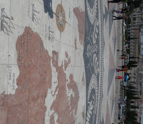
In the fifteenth century, Portuguese explorers used caravels, small and manoeuvrable ships with triangular sails that allowed the vessels to sail close to the wind, and a shallow keel ideal for sailing in coastal waters. The map depicts caravels and gives dates and locations of Portuguese discoveries. In order to support trading activities, the Portuguese royalty established a centre for the study of navigation, ship design and astronomy. As a result, Portuguese maps of the fifteenth century were the best in Europe and highly sought after. Theft of trading route maps across Europe led the Portuguese to safeguard their maps by giving them the status of state secrets.
 |
 |
The combination of fast ships, royal investment in exploration and a pioneering spirit, led to the establishment of Portuguese ports in Africa and Asia. Portuguese navigator and explorer Vasco da Gama was the first captain to sail from Europe to India, discovering a route around the Cape of Good Hope, reaching the Indian coast at Calecut (now called Kozhikode in the state of Kerela) in 1498 and helping to establish Portuguese trading posts in India and Mozambique.
 |
 |
| Vasco da Gama | Ferdinand Magellan |
Da Gama was followed by another famous Portuguese explorer, Ferdinand Magellan who was involved in a series of expeditions to India, Africa and Malaysia. Intent on finding alternative routes for the valuable spice trade, he set off in 1519 to cross the Atlantic in search of a westwards route to the spice islands of Indonesia. His epic voyage took him round the southern point of South America, via the western Pacific and on to the Philippines. Magellan met his death during a dispute with local tribes there, but one ship from his fleet returned in 1522, completing the first circumnavigation of the world.
 |
 |
| Antique world map by Hondius as wallpaper | Detail of South America |
Take inspiration from the 'Age of Discovery' in your home with an antique world map from Love Maps On. Our Hondius map is one of the most beautiful of the period, with decorative borders that depict explorers and cartographers of the age. The close-up image above shows the Strait of Magellan, the passage that Magellan first took around the southern tip of South America. Choose the Hondius map as wallpaper or as a canvas print.
'On the Map: Why the World Looks the Way it Does' May 09 2014

Exploring the cultural and historical significance of maps, 'On the Map: Why the World Looks the Way it Does' tells the stories of early mapmakers such as Greek scholar Ptolomy and the traders who discovered new territories and expanded our understanding of the world. Simon Garfield's book on map making through the ages was amongst the gifts in the Love Maps On Christmas stocking. We love learning about influential maps and cartographers, ancient and modern, so this gift was just perfect!
It's an engaging read and we really enjoyed Garfield's insights into significant historical maps that have been hidden over the centuries and the stories of those who rediscovered them, recognising their importance and bringing them back to public view. These include the famous medieval Mappa Mundi in Hereford Cathedral and Venetian monk Fra Mauro's 15th-century map of the world which was heavily influenced by Marco Polo's travels almost two centuries after his expeditions.
'On the Map' brings the story of cartography right up to date with the latest satnav technology, GPS and map apps that place each of us, as individuals, at the centre of the map. Garfield explores how the digital revolution is transforming mapping more than any previous innovations in cartography. If you'd like to learn more about the book, visit Simon Garfield's website.
City Maps from History April 07 2014
Reading a fascinating feature from the Guardian on 'Ten city maps from history' reminded us that historical maps can be informative and attractive.
The collection shows how early city maps evolved from simple representations of what could be seen on the ground, through to more detailed graphics that communicated complex economic or social ideas. The featured maps include an 1812 map of the area devastated by the great fire of Moscow and Charles Booth's 1891 poverty map of London which provided a survey of life and labour across boroughs.
Want to take inspiration from historical city maps for your home decor? Love Maps On brings you Ordnance Survey maps of London dating from 1805 and 1897, an era when London was the world's largest city and capital of the British Empire.

Ordnance Survey Old Series, London, 1805 - the first national mapping series of England and Wales.


Ordnance Survey Revised New Series, London, 1897 - the first colour mapping series of England and Wales.
The maps show London at a time when the city was expanding rapidly and its population grew from one million to more than six million people. London was transformed by the development of the railway network and the urbanised area spread to Islington, Paddington, Holborn, Camden, Southwark and Lambeth. You can choose the maps printed on canvas in a choice of four sizes.

Stanford's map of London, 1891 (close up showing the Thames, Tower of London and Fenchurch Street station).
To make a snapshot of history a fabulous wall feature, you can choose a London vintage map as a wallpaper. Love Maps On provides wallpaper of Stanford's street map of central London from 1891 at 1:10,560 scale, showing fascinating detail of the wharves, customs houses, guild halls, warehouses and trading exchanges that made London a mighty port city. Our wallpapers are available in a variety of sizes printed on paper or fabric material.
We will be adding vintage maps from across Great Britain to our collection soon, so look out for our historical maps of your favourite cities and places.
If you'd like to chat to us about our maps and what we can do for you, just contact us or drop us an email to hello@lovemapson.com.
From Walk to Wall February 20 2014
At long last the days are stretching out and, after hibernating at home for what feels like months, we're starting to look ahead to spring walks and rediscovering the great outdoors. There's something exciting about unfolding an Ordnance Survey map and planning a trip.
If, like us, you love Ordnance Survey maps, you could make one a feature in your home. The next time you're thinking of adding a photo or artwork to an empty space on the wall, why not hang a map instead? Love Maps On custom make wallpaper, canvases and posters of Ordnance Survey maps centred on the postcode you specify in Great Britain.
Choose from a 1:10,000 scale street map that's ideal for towns and cities, showing the detail of street names, parks and buildings.
 |
 |
| Example of our Custom Ordnance Survey Street Map Classic Wallpaper | Close up of Ordnance Survey 1:10,000 scale street map |
Alternatively, a 1:25,000 scale map – based on the popular Explorer® map series for outdoor activities - shows a larger ground distance and is suitable for rural and urban locations. At this scale, you get an overview of the area with contours, buildings, roads and paths shown.
 |
 |
| Example of our Custom Ordnance Survey Explorer Map Wallpaper | Close up of Ordnance Survey 1:25,000 scale Explorer® map |
Wallpaper is currently available at two set sizes; 200 x 180 cm and 350 x 240 cm and comes either paper backed or fabric backed. We'll provide you with a pasting kit to make applying it easier. Posters are available in standard (A1), medium (A0), large and extra large sizes.
If you'd like to chat to us about the options, just contact us or drop us an email to hello@lovemapson.com.

Recent Articles
Hill-shaded OS maps for trail runners and walkers Posted on October 14, 2019
Ships, clock and stars: The Quest for Longitude Posted on March 09, 2015
The 'Age of Discovery' in maps Posted on August 07, 2014
'On the Map: Why the World Looks the Way it Does' Posted on May 09, 2014
City Maps from History Posted on April 07, 2014
From Walk to Wall Posted on February 20, 2014