Choosing a map for your wall.
Our experts can guide you every step of the way when choosing the right map for your wall.
Shown below are the various types of Ordnance Survey mapping available - both present-day and vintage. Each can be centred on any postcode in England, Scotland or Wales. Each can be re-coloured to your requirements
We're here to advise you should you have any questions. Please email us or ring 07352 347537 to discuss your requirements with our cartographers.
Once you have decided which map would best suit your needs fill in our Get a Quote form and request a free* digital proof.
* As part of our proofing service we will provide up to three proofs free of charge at the company’s discretion. Further proofs will incur a cost based on the number of proofs required and the estimated time for redesign by our cartographers.
Present-day Ordnance Survey Maps.
These vary in scale from high detail street mapping to regional mapping so your choice of map will depend on how much detail you want shown and how large an area you want covered.
 High Detail Street Map, this is the most detailed mapping we have for the UK and shows individual buildings, land areas, boundaries and street names. This mapping should be used for showing small areas where the greatest amount of detail is required and is ideal for built up areas. The roads are categorised by colour with buildings, water features and park areas also picked out in colour. Street and building names are shown in black. Should you decide these colours aren't for you we can re-colour the map to suit your particular needs.
 Street Map and Street Map Classic (1:10,000) use a more basic level of Ordnance Survey street mapping. Their application is the same as the high-detail version map, but with less detailed linework. Ideal for built up areas but not suitable for rural areas. The colouring shown here is of the Traditional style of Street Map using yellows and oranges. Street Map Classic uses subtle red/brown pastel tones. This map type can also be re-coloured.
 Ordnance Survey Explorer map (1:25,000) is a great all round map, while still showing a good amount of detail the map can zoom out to cover a much larger area than street maps. Street names are not shown, but detail such as drainage, buildings, footpaths, bridleways and field boundaries is clear. With the addition of contours the varying land heights can be seen in more rural areas making this map suitable for both rural and town areas.
 Ordnance Survey Landranger Map (1:50,000) is similar in style to the above Explorer map but has a lower level of detail allowing greater geographical coverage. Built up areas are shown as a generalised area rather than as individual buildings. This map is perfect for covering large areas allowing for more than one town to be shown if required. The contours showing interesting detail in the rural areas.
 Ordnance Survey Landranger Map with Hillshading (1:50,000) is the same as the standard Landranger Map but with added hillshading to give the map a fantastic feeling of depth when displayed on a wall. The hillshading works best in more rural and hilly areas. If you're not sure whether your area of interest would suit hillshading then please contact our cartographers for advice.
 GB Regional Mapping (1:250,000) is a road atlas style map with added hillshading, showing the main road and rail network, drainage and towns across the UK with places of interest displayed as blue symbols. Contours and hillshading are included within the detail giving good general interest to large areas of the country. This mapping is also available as a whole UK map or as pre-defined regions.
Ordnance Survey Vintage Maps
Love Maps On employs some of the UKs leading experts in historical Ordnance Survey mapping. We have exclusive access to the UKs largest collection of vintage mapping in range of scales.
 High Detail Victorian Street Mapping (1:2,500) is our most detailed vintage map published from the mid 19th century. Best for covering small areas with the most amount of detail which includes, street names, buildings, naming of larger buildings, areas of vegetation, land and field boundaries. This mapping was originally monotone however it can be provided with a sepia/ageing tint, or tinted to a colour of your choice, contact us for more information.
 Victorian Street Mapping (1:10560) is less detailed than the above mapping but still maintains a high level of detail which includes street names, buildings and field boundaries. This is best used for built up areas and extended rural areas. This mapping was originally monotone, however it can be provided with a sepia/ageing tint, or tinted to a colour of your choice, contact us for more information.
 Ordnance Survey Old Series 1805 -1895 (1:63,360). This is a good map for showing larger geographical extents of both towns and rural areas. Detail includes road, rail and drainage networks, town and village names. Hachuring has been used to show the varying land heights which, when view from a distance has a stunning almost 3D effect. (N.B. Hachuring in mountainous areas can be very detailed and may appear to overwhelm the map detail).
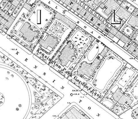 Vintage London Town Plans These are highly detailed plans of London from the 19th century at a scale of 1:1056. As well as showing buildings, street names, property boundaries and parks, features such as pathways, trees and lamp posts can also be seen. These beautifully drawn maps are ideal for coverage of small areas of greatest detail of London. This mapping was originally monotone however it can be provided with a sepia/ageing tint, or tinted to a colour of your choice, contact us for a quote.