The 'Age of Discovery' in maps August 07 2014
On a recent trip to Lisbon in Portugal, we found this wonderful world map mosaic. The huge marble floor map shows Portugal's achievements as the first global sea power and celebrates the voyages of Portugal's explorers in the 'Age of Discovery' during the fifteenth and sixteenth centuries. We love maps with historical significance and antique flourishes and we're taking inspiration from this beautiful example.
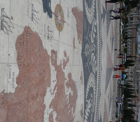
In the fifteenth century, Portuguese explorers used caravels, small and manoeuvrable ships with triangular sails that allowed the vessels to sail close to the wind, and a shallow keel ideal for sailing in coastal waters. The map depicts caravels and gives dates and locations of Portuguese discoveries. In order to support trading activities, the Portuguese royalty established a centre for the study of navigation, ship design and astronomy. As a result, Portuguese maps of the fifteenth century were the best in Europe and highly sought after. Theft of trading route maps across Europe led the Portuguese to safeguard their maps by giving them the status of state secrets.
 |
 |
The combination of fast ships, royal investment in exploration and a pioneering spirit, led to the establishment of Portuguese ports in Africa and Asia. Portuguese navigator and explorer Vasco da Gama was the first captain to sail from Europe to India, discovering a route around the Cape of Good Hope, reaching the Indian coast at Calecut (now called Kozhikode in the state of Kerela) in 1498 and helping to establish Portuguese trading posts in India and Mozambique.
 |
 |
| Vasco da Gama | Ferdinand Magellan |
Da Gama was followed by another famous Portuguese explorer, Ferdinand Magellan who was involved in a series of expeditions to India, Africa and Malaysia. Intent on finding alternative routes for the valuable spice trade, he set off in 1519 to cross the Atlantic in search of a westwards route to the spice islands of Indonesia. His epic voyage took him round the southern point of South America, via the western Pacific and on to the Philippines. Magellan met his death during a dispute with local tribes there, but one ship from his fleet returned in 1522, completing the first circumnavigation of the world.
 |
 |
| Antique world map by Hondius as wallpaper | Detail of South America |
Take inspiration from the 'Age of Discovery' in your home with an antique world map from Love Maps On. Our Hondius map is one of the most beautiful of the period, with decorative borders that depict explorers and cartographers of the age. The close-up image above shows the Strait of Magellan, the passage that Magellan first took around the southern tip of South America. Choose the Hondius map as wallpaper or as a canvas print.
